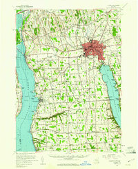
1956 Map of Auburn
USGS Topo · Published 1961About this map
Auburn dominates this mid-century portrait of Cayuga County, positioned as a major industrial and transit hub between the fingers of Cayuga Lake and Owasco Lake. The city layout reflects its nineteenth-century roots, prominently featuring the State Prison and a network of schools like Lincoln Sch and Seward Sch. The landscape is a corridor for major transport, showing the New York State Thruway in the north and the intersecting tracks of the Lehigh Valley Railroad and New York Central Railroad. To the west, the Montezuma National Wildlife Refuge borders the Seneca River, while the lakeshore is dotted with landmarks like Ellis Pt Lighthouse and various seasonal destinations such as Camp Columbus. Smaller settlements like Union Springs and Half Acre maintain their distinct identities amidst the agricultural expanses and rural cemeteries like Old Quaker Cem that reveal the deep family history of the region.
Find a feature on this map
138 named features on this map. Tap any name to fly to it.
Don’t see what you’re looking for? This feature index may not catch every label — zoom into the map to look around manually.
Map Details
Editions of this 1956 Auburn Map
2 editions found
Other maps of this area

1898 · Moravia
USGS Topo · 1:62,500

1899 · Auburn
USGS Topo · 1:62,500

1899 · Skaneateles
USGS Topo · 1:62,500

1900 · Baldwinsville
USGS Topo · 1:62,500

1902 · Skaneateles
USGS Topo · 1:62,500

1902 · Geneva
USGS Topo · 1:62,500

1902 · Clyde
USGS Topo · 1:62,500

1902 · Moravia
USGS Topo · 1:62,500

1902 · Genoa
USGS Topo · 1:62,500

1902 · Ovid
USGS Topo · 1:62,500