
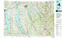
1986 Map of Auburn
USGS Topo · Published 1986About this map
Seneca Lake and Cayuga Lake dominate the Finger Lakes landscape in this mid-1980s representation of Central New York. Between these two great bodies of water, the Seneca Army Depot and its associated Seneca Army Airfield occupy a massive footprint, reflecting the region's mid-century military importance. To the north, the Montezuma National Wildlife Refuge marks the transition from the lakes to the Seneca River system, while the New York State Thruway cuts a modern corridor across the northern edge of the map.
Find a feature on this map
87 named features on this map. Tap any name to fly to it.
Don’t see what you’re looking for? This feature index may not catch every label — zoom into the map to look around manually.
Map Details
Editions of this 1986 Auburn Map
2 editions found
Other maps of this area

1893 · Ithaca
USGS Topo · 1:62,500

1895 · Chittenango
USGS Topo · 1:62,500
1895 · Ithaca
USGS Topo · 1:62,500

1895 · Syracuse
USGS Topo · 1:62,500

1897 · Cazenovia
USGS Topo · 1:62,500

1898 · Syracuse
USGS Topo · 1:62,500

1898 · Moravia
USGS Topo · 1:62,500

1898 · Chittenango
USGS Topo · 1:62,500
1898 · Watkins Glen
USGS Topo · 1:62,500

1899 · Auburn
USGS Topo · 1:62,500