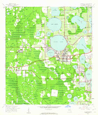
1944 Map of Auburndale
USGS Topo · Published 1963About this map
Auburndale serves as the central hub of this mid-century landscape, positioned at a critical junction of rail and road. The local economy and transportation network are defined by the Atlantic Coast Line and Seaboard Air Line railroads, which weave through a region dominated by citrus groves and a dense cluster of lakes. The map documents smaller rural communities like Lynchburg, Fussells Corner, and Jones Corner, alongside educational landmarks such as Carver Sch and Innwood Sch.
Find a feature on this map
43 named features on this map. Tap any name to fly to it.
Don’t see what you’re looking for? This feature index may not catch every label — zoom into the map to look around manually.
Map Details
Editions of this 1944 Auburndale Map
2 editions found
Other maps of this area

1944 · Providence
USGS Topo · 1:31,680

1944 · Polk City
USGS Topo · 1:31,680

1944 · Lakeland
USGS Topo · 1:31,680

1944 · Auburndale
USGS Topo · 1:31,680

1949 · Mulberry
USGS Topo · 1:24,000

1949 · Bartow
USGS Topo · 1:24,000

1950 · Mulberry
USGS Topo · 1:24,000

1950 · Bartow
USGS Topo · 1:24,000

1955 · Eloise
USGS Topo · 1:24,000

1955 · Orlando
USGS Topo · 1:250,000