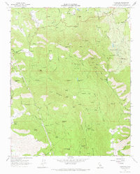
1966 Map of Auckland
USGS Topo · Published 1967About this map
Auckland and its surrounding ranchlands appear here in the mid-1960s, defined by a network of springs and canyons in the foothills of the Sierra Nevada. The settlement pattern is characterized by scattered family holdings and specialized agricultural sites, such as the Auckland Ranch, Dudley Ranch, and the Pacific Coast Equestrian Research Farm. The prominence of water sources like Schoolhouse Spring, Indian Painting Spring, and Warm Sulfur Spring underscores the importance of reliable water in this terrain, where seasonal drainages like Cottonwood Creek and Minnehaha Creek carve through the landscape.
Find a feature on this map
78 named features on this map. Tap any name to fly to it.
Don’t see what you’re looking for? This feature index may not catch every label — zoom into the map to look around manually.
Map Details
Editions of this 1966 Auckland Map
2 editions found
Other maps of this area

1903 · Tehipite
USGS Topo · 1:125,000

1904 · Kaweah
USGS Topo · 1:125,000

1905 · Tehipite
USGS Topo · 1:125,000

1909 · Kaweah
USGS Topo · 1:125,000

1921 · Stokes Mountain
USGS Topo · 1:24,000

1922 · Trimmer
USGS Topo · 1:96,000

1924 · Dinuba
USGS Topo · 1:125,000

1924 · Stokes Mountain
USGS Topo · 1:31,680

1926 · Ivanhoe
USGS Topo · 1:31,680

1928 · Lemon Cove
USGS Topo · 1:31,680