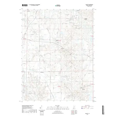
2019 Map of Augusta
USGS Topo · Published 2019About this map
Augusta and Stendal anchor this Pike County landscape, where the meandering drainage of the Patoka River and its southern forks defines the terrain. The map documents a rural corridor transitioning between agricultural fields and industrial extraction, most notably at Hoskins Pits and the Corn-Gem site. For those tracing local history, several small cemeteries are preserved among the township grids, including Augusta Cem, Barret Cem, and Saint Peters Cem near the southern boundary. Settlement patterns follow the historic county roads and the paths of former rail junctions like Hartwell Junction. The hydrology is complex, featuring managed waterways such as Barren Ditch and natural flows through Clifford Cr and Beadens Cr. High points like Mitchell Plain provide a glimpse into the geographic character of the region, while naming conventions for routes like the Pike Forest Horse TRL suggest a landscape used for both work and modern recreation.
Find a feature on this map
57 named features on this map. Tap any name to fly to it.
Don’t see what you’re looking for? This feature index may not catch every label — zoom into the map to look around manually.
Map Details
Editions of this 2019 Augusta Map
This is the sole edition of this map. No revisions or reprints were ever made.
Other maps of this area

1900 · De Gonia Springs
USGS Topo · 1:62,500

1902 · Ditney
USGS Topo · 1:125,000

1902 · Degonia Springs
USGS Topo · 1:62,500

1902 · Boonville
USGS Topo · 1:62,500

1903 · Velpen
USGS Topo · 1:62,500

1903 · Petersburg
USGS Topo · 1:62,500

1956 · Vincennes
USGS Topo · 1:250,000

1957 · Vincennes
USGS Topo · 1:250,000

1958 · Vincennes
USGS Topo · 1:250,000
1960 · Folsomville
USGS Topo · 1:24,000