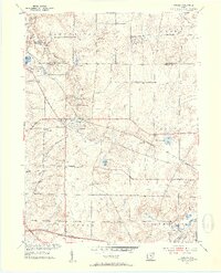
1953 Map of Aurora
USGS Topo · Published 1954About this map
The Aurora and Taborville areas in the early 1950s showcase a transition between agricultural land and emerging suburban development within the Connecticut Western Reserve. This survey period finds the Ohio Turnpike Under Construction across the southern edge of the map, a massive infrastructure project that would soon reshape regional travel and local property lines. Small lakes and water features define the landscape, from the prominent Sunny Lake and Round-up Lake to the Waterfall and the winding Aurora Branch. Local history is preserved in the location of the Plainview Ch and the Fowler Cem, while the industrial and recreational character of the era is evident at the Sand Pit near Geauga Lake and the YMCA Camp. The Erie railroad corridor remains a primary transit artery, cutting diagonally through the townships of Bainbridge and Aurora.
Find a feature on this map
35 named features on this map. Tap any name to fly to it.
Don’t see what you’re looking for? This feature index may not catch every label — zoom into the map to look around manually.
Map Details
Editions of this 1953 Aurora Map
2 editions found
Other maps of this area

1905 · Garrettsville
USGS Topo · 1:62,500

1906 · Kent
USGS Topo · 1:62,500

1906 · Chagrin Falls
USGS Topo · 1:62,500

1906 · Ravenna
USGS Topo · 1:62,500

1907 · Garrettsville
USGS Topo · 1:62,500

1908 · Chagrin Falls
USGS Topo · 1:62,500

1908 · Ravenna
USGS Topo · 1:62,500

1950 · Cleveland
USGS Topo · 1:250,000

1953 · South Russell
USGS Topo · 1:24,000

1953 · Aurora
USGS Topo · 1:24,000