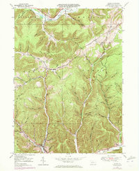
1948 Map of Austin
USGS Topo · Published 1972About this map
Austin serves as the focal point of this Potter County landscape, situated at the confluence of several steep valleys where Freeman Run flows south. This 1948 survey, photorevised in the early 1970s, captures the post-industrial character of the region as former timber and transport routes evolved. An Old Railroad Grade follows the curve of the Allegheny River near Mina and Olmsted in the north, while a Pipe Line and Pumping Sta signal the infrastructure of the energy industry. Smaller settlements and local landmarks like Inez and the Inez Sch are tucked into the high hollows of the Eulalia and Homer districts. The terrain is defined by a dense network of family-named drainages such as McNamara Hol and Chastain Hol, reflecting the deep-rooted local history of these mountain gaps.
Find a feature on this map
79 named features on this map. Tap any name to fly to it.
Don’t see what you’re looking for? This feature index may not catch every label — zoom into the map to look around manually.
Map Details
Editions of this 1948 Austin Map
4 editions found
Other maps of this area

1932 · Genesee
USGS Topo · 1:62,500

1934 · Coudersport
USGS Topo · 1:48,000

1937 · Genesee
USGS Topo · 1:62,500

1938 · Coudersport
USGS Topo · 1:62,500

1947 · Conrad
USGS Topo · 1:62,500

1947 · Conrad
USGS Topo · 1:24,000

1947 · Ayers Hill
USGS Topo · 1:24,000

1948 · Emporium
USGS Topo · 1:62,500

1948 · Keating Summit
USGS Topo · 1:24,000

1948 · Emporium
USGS Topo · 1:24,000