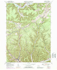
1948 Map of Austin
USGS Topo · Published 1989About this map
Austin sits at the southern confluence of several mountain streams in the high Allegheny Plateau, where the waters of Freeman Run and its various branches meet. This 1948 survey reveals a landscape deeply carved by numerous hollows, including Bark Shanty Hollow and Hoxie Hollow, which dictate the placement of local roads and small settlements. The upper reaches of the Allegheny River cut through the northern edge of the quadrangle near Mina, while the southern border features the First Fork Sinnemahoning Creek. An Old Railroad Grade follows the river valley, marking the legacy of the region's early timber and industrial transport network. Isolated rural landmarks like the Inez Sch and a Pumping Sta reflect the sparse but persistent development within the townships of Roulette, Eulalia, and Sylvania.
Find a feature on this map
67 named features on this map. Tap any name to fly to it.
Don’t see what you’re looking for? This feature index may not catch every label — zoom into the map to look around manually.
Map Details
Editions of this 1948 Austin Map
4 editions found
Other maps of this area

1932 · Genesee
USGS Topo · 1:62,500

1934 · Coudersport
USGS Topo · 1:48,000

1937 · Genesee
USGS Topo · 1:62,500

1938 · Coudersport
USGS Topo · 1:62,500

1947 · Conrad
USGS Topo · 1:62,500

1947 · Conrad
USGS Topo · 1:24,000

1947 · Ayers Hill
USGS Topo · 1:24,000

1948 · Emporium
USGS Topo · 1:62,500

1948 · Keating Summit
USGS Topo · 1:24,000

1948 · Emporium
USGS Topo · 1:24,000