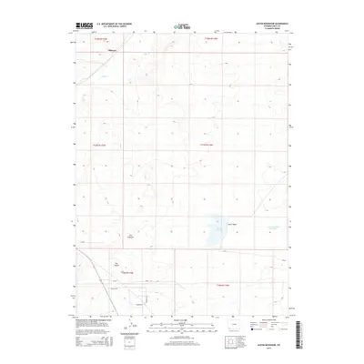
2015 Map of Austin Reservoir
USGS Topo · Published 2015About this map
Elkhurst sits in the high desert landscape of Wyoming's Uinta County, serving as a focal point for the surrounding cattle country. The terrain is defined by distinct geologic markers, most notably the prominent rises of The Pinnacle and The Nipple, which provide navigational landmarks across the arid plains. Water management is central to life in this environment, as evidenced by the namesake Austin Reservoir and the Powers Stock Reservoir, both critical for sustaining livestock in a region where natural drainage like Muddy Cr and Austin Wash can be ephemeral.
Find a feature on this map
19 named features on this map. Tap any name to fly to it.
Don’t see what you’re looking for? This feature index may not catch every label — zoom into the map to look around manually.
Map Details
Editions of this 2015 Austin Reservoir Map
This is the sole edition of this map. No revisions or reprints were ever made.
Other maps of this area

1954 · Ogden
USGS Topo · 1:250,000

1958 · Ogden
USGS Topo · 1:250,000

1960 · Ogden
USGS Topo · 1:250,000

1964 · Fort Bridger
USGS Topo · 1:24,000

1964 · Carter
USGS Topo · 1:24,000

1964 · Mountain View
USGS Topo · 1:24,000

1964 · Austin Reservoir
USGS Topo · 1:24,000
1965 · Millersville
USGS Topo · 1:24,000
1965 · Turtle Hill
USGS Topo · 1:24,000

1969 · Hampton
USGS Topo · 1:24,000