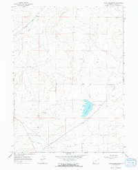
1964 Map of Austin Reservoir
USGS Topo · Published 1968About this map
Elkhurst and the surrounding high plains of Uinta County are defined by a network of water management and transportation infrastructure in this mid-1960s survey. The landscape is dominated by the Austin Reservoir, which captures flow from the surrounding watershed, and the extensive Austin Canal system that cuts across the terrain to support local agriculture and livestock. In the northwest, the Union Pacific railroad tracks follow the course of Muddy Creek, a corridor that has historically linked this portion of Wyoming to broader western commerce. Natural landmarks such as The Pinnacle and The Nipple rise above the drainage of the Wash, providing distinctive navigation points in a region also marked by modern pipelines. The map documents a period when rural industrial infrastructure began to overlay the traditional ranching landscape, visible in the spillway elevations and canal paths that divert water through the arid basin.
Find a feature on this map
11 named features on this map. Tap any name to fly to it.
Don’t see what you’re looking for? This feature index may not catch every label — zoom into the map to look around manually.
Map Details
Editions of this 1964 Austin Reservoir Map
2 editions found
Other maps of this area

1954 · Ogden
USGS Topo · 1:250,000

1958 · Ogden
USGS Topo · 1:250,000

1960 · Ogden
USGS Topo · 1:250,000

1964 · Fort Bridger
USGS Topo · 1:24,000

1964 · Carter
USGS Topo · 1:24,000

1964 · Mountain View
USGS Topo · 1:24,000

1964 · Austin Reservoir
USGS Topo · 1:24,000
1965 · Millersville
USGS Topo · 1:24,000
1965 · Turtle Hill
USGS Topo · 1:24,000

1969 · Hampton
USGS Topo · 1:24,000