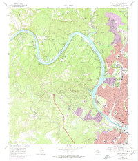
1966 Map of Austin West
USGS Topo · Published 1974About this map
Lake Austin and the winding Colorado River define the topography of this mid-century survey, documenting the transition of the Jollyville Plateau from rural land to suburban expansion. While the capital city of Austin dominates the eastern edge, the western hills show a landscape of rising peaks like Mount Bonnell and Mount Larson alongside established institutions. Local history is deeply etched into the map through sites like the Treaty Oak, the Texas Confederate Home, and several family burial grounds including Preece Cem and Tucker Cem. The presence of the Camp Mabry Military Reservation and the Austin State Sch indicates the area's role as a hub for state and military infrastructure. Modern development in the 1970s is highlighted by purple revisions, marking the growth of communities like Rollingwood and West Lake Hills near the banks of Town Lake.
Find a feature on this map
59 named features on this map. Tap any name to fly to it.
Don’t see what you’re looking for? This feature index may not catch every label — zoom into the map to look around manually.
Map Details
Editions of this 1966 Austin West Map
4 editions found
Other maps of this area

1896 · Austin
USGS Topo · 1:125,000

1897 · Austin
USGS Topo · 1:125,000

1910 · Austin
USGS Topo · 1:125,000

1930 · Austin-2
USGS Topo · 1:48,000

1932 · Mt. Bonnell
USGS Topo · 1:62,500

1954 · Austin East
USGS Topo · 1:24,000

1954 · Austin West
USGS Topo · 1:24,000

1954 · Austin
USGS Topo · 1:250,000

1955 · Montopolis
USGS Topo · 1:24,000

1955 · Oak Hill
USGS Topo · 1:24,000