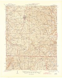
1945 Map of Ava
USGS Topo · Published 1945About this map
Ava serves as the regional hub for this Ozark landscape, where the town grid stands in contrast to the deep winding hollows and ridges of the surrounding countryside. This 1940s-era mapping of Douglas and Ozark counties reveals a decentralized network of rural life, anchored by dozens of one-room schoolhouses like Nubbin Ridge Sch and Loftin Sch. The southern portion of the map is dominated by the Mark Twain National Forest, which covers the terrain near the Little North Fork White River.
Find a feature on this map
93 named features on this map. Tap any name to fly to it.
Don’t see what you’re looking for? This feature index may not catch every label — zoom into the map to look around manually.
Map Details
Editions of this 1945 Ava Map
2 editions found

Other maps of this area

1934 · Gainesville
USGS Topo · 1:48,000

1936 · Thornfield
USGS Topo · 1:48,000

1936 · Ava
USGS Topo · 1:48,000

1937 · Buckhart
USGS Topo · 1:48,000

1937 · Bradleyville
USGS Topo · 1:48,000

1939 · Fordland
USGS Topo · 1:62,500

1940 · Gainesville
USGS Topo · 1:62,500

1942 · Fordland
USGS Topo · 1:62,500

1942 · Ava
USGS Topo · 1:62,500

1943 · Protem
USGS Topo · 1:62,500