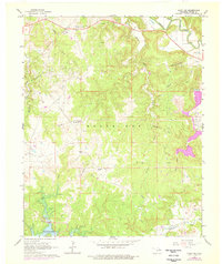
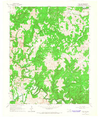
1966 Map of Avant SW
USGS Topo · Published 1976About this map
Oil wells and complex industrial infrastructure dominate this mid-century landscape in the Osage Nation, where petroleum extraction defines the terrain. Large-scale operations such as the Wildhorse Oil Field, Branstetter Oil Field, and Black Dog are interconnected by a network of pipelines and facilities like the tank farm near Morgans Corner. This era of intensive land use is punctuated by localized agricultural holdings, including the Triple M Ranch and Arrowhead Ranch.
Find a feature on this map
27 named features on this map. Tap any name to fly to it.
Don’t see what you’re looking for? This feature index may not catch every label — zoom into the map to look around manually.
Map Details
Editions of this 1966 Avant SW Map
3 editions found
Other maps of this area

1912 · Hominy
USGS Topo · 1:125,000

1915 · Hominy
USGS Topo · 1:125,000

1915 · Hominy
USGS Topo · 1:62,500

1955 · Enid
USGS Topo · 1:250,000

1956 · Sand Springs
USGS Topo · 1:24,000

1958 · Enid
USGS Topo · 1:250,000

1958 · Keystone Dam
USGS Topo · 1:24,000

1958 · Wekiwa
USGS Topo · 1:24,000
1963 · Avant SE
USGS Topo · 1:24,000
1966 · Avant NW
USGS Topo · 1:24,000