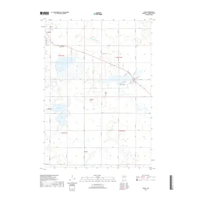
2019 Map of Avoca
USGS Topo · Published 2019About this map
The Coteau des Prairies upland defines this corner of Murray County, where the village of Avoca sits along the southern shore of Lime Lake. This landscape is marked by a distinctive hydrological pattern, including the expansive Big Slough and the connected waters of North Badger Lake and South Badger Lake. The agricultural heritage of the region is evident in the straight lines of Judicial Ditch Number Ten and a dense network of township roads like 91st St and 71st St that grid the prairie. Genealogists will find a high concentration of burial sites serving various early congregations, from the Badger Lake Presbyterian Cem in the southwest to Saint Annes Cem near Slayton and Saint Rose Cem in the heart of Avoca. The small settlement of Wirock remains visible in the southern townships, anchored at the junction of 31st St and the section line.
Find a feature on this map
43 named features on this map. Tap any name to fly to it.
Don’t see what you’re looking for? This feature index may not catch every label — zoom into the map to look around manually.
Map Details
Editions of this 2019 Avoca Map
This is the sole edition of this map. No revisions or reprints were ever made.
Other maps of this area

1953 · New Ulm
USGS Topo · 1:250,000

1954 · Fairmont
USGS Topo · 1:250,000

1957 · New Ulm
USGS Topo · 1:250,000

1958 · New Ulm
USGS Topo · 1:250,000

1958 · Fairmont
USGS Topo · 1:250,000

1967 · New Ulm
USGS Topo · 1:250,000

1967 · Slayton
USGS Topo · 1:24,000

1967 · Wilmont
USGS Topo · 1:24,000

1967 · Hadley
USGS Topo · 1:24,000

1967 · Dovray
USGS Topo · 1:24,000