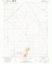
1951 Map of Avon NW
USGS Topo · Published 1979About this map
Johnston Ranch serves as a primary marker of human settlement in this high-desert landscape of Iron County, which was surveyed in 1951. The transportation corridor is dominated by the diagonal path of the Union Pacific railroad, which cuts across the arid terrain. Natural drainage patterns are defined by the Dick Palmer Wash, which winds through the central and eastern sections. In an area where water is a vital resource, the locations of Websters Well and various windmills indicate the reliance on groundwater to support ranching operations. The topography is largely characterized by broad basins, interrupted only by the prominent rise of Table Butte in the southern portion of the quadrangle. Other navigational and utility markers include a localized Water Tank and an Airway Beacon, which reflect the mid-century infrastructure required for both rail and aerial transit across this expansive region.
Find a feature on this map
12 named features on this map. Tap any name to fly to it.
Don’t see what you’re looking for? This feature index may not catch every label — zoom into the map to look around manually.
Map Details
Editions of this 1951 Avon NW Map
3 editions found
Other maps of this area

1885 · St. George
USGS Topo · 1:250,000

1891 · St. George
USGS Topo · 1:250,000

1950 · Antelope Peak
USGS Topo · 1:24,000

1950 · Avon SE
USGS Topo · 1:24,000

1951 · Avon SE
USGS Topo · 1:24,000

1951 · Avon
USGS Topo · 1:24,000

1951 · Avon NW
USGS Topo · 1:24,000

1953 · Richfield
USGS Topo · 1:250,000

1953 · Cedar City
USGS Topo · 1:250,000

1958 · Richfield
USGS Topo · 1:250,000