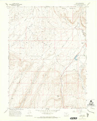
1966 Map of Axial
USGS Topo · Published 1970About this map
Axial Basin dominates this mid-century landscape of Moffat County, where high-country ranching and resource extraction define the local economy. The settlement of Axial serves as a central point near Good Spring Creek, while the presence of the Streeter Mine and Mount Streeter further south highlights the region's industrial ties. Land ownership and agricultural legacy are evident through established family-named properties like the Wilson Ranch, Gossard Ranch, and the Circle Bar Ranch located along the eastern edge of the quadrangle.
Find a feature on this map
25 named features on this map. Tap any name to fly to it.
Don’t see what you’re looking for? This feature index may not catch every label — zoom into the map to look around manually.
Map Details
Editions of this 1966 Axial Map
2 editions found
Other maps of this area

1910 · Danforth Hills
USGS Topo · 1:125,000

1912 · Meeker
USGS Topo · 1:62,500

1912 · Axial
USGS Topo · 1:62,500

1914 · Meeker
USGS Topo · 1:62,500

1914 · Axial
USGS Topo · 1:62,500

1915 · Monument Butte
USGS Topo · 1:62,500

1954 · Craig
USGS Topo · 1:250,000

1957 · Craig
USGS Topo · 1:250,000

1958 · Craig
USGS Topo · 1:250,000

1960 · Craig
USGS Topo · 1:250,000