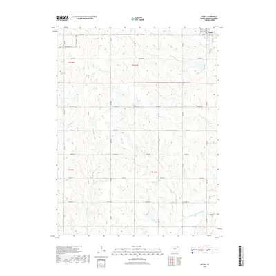
2018 Map of Axtell
USGS Topo · Published 2018About this map
Axtell anchors the northeastern corner of this Marshall County landscape, where the street grid of Maple St, Prairie St, and S Eight St marks the town's extent. The surrounding countryside is defined by a systematic network of section-line roads with distinct names like Ironstone Rd, Jayhawk Rd, and Limestone Rd. This late 2010s survey captures the agricultural heart of the region, where the terrain is carved by the N Fork Black Vermillion River and its various tributaries including Snipe Cr and Little Timber Cr. For those researching local heritage, the Mission Covenant Cem sits centrally along Limestone Rd, serving as a quiet landmark amidst the vast fields of Township 2 South, Range 10 East.
Find a feature on this map
23 named features on this map. Tap any name to fly to it.
Don’t see what you’re looking for? This feature index may not catch every label — zoom into the map to look around manually.
Map Details
Editions of this 2018 Axtell Map
This is the sole edition of this map. No revisions or reprints were ever made.
Other maps of this area

1889 · Seneca
USGS Topo · 1:125,000

1894 · Seneca
USGS Topo · 1:125,000

1955 · Manhattan
USGS Topo · 1:250,000

1956 · Manhattan
USGS Topo · 1:250,000

1957 · Manhattan
USGS Topo · 1:250,000
1966 · Seneca NW
USGS Topo · 1:24,000

1966 · Baileyville
USGS Topo · 1:24,000

1966 · Axtell
USGS Topo · 1:24,000
1966 · Summerfield
USGS Topo · 1:24,000
1966 · Beattie
USGS Topo · 1:24,000