
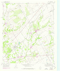
1956 Map of Axtell
USGS Topo · Published 1957About this map
Mount Calm and Axtell anchor this mid-century landscape where the borderlines of McLennan, Hill, and Limestone counties converge. The St Louis Southwestern railroad cuts a straight diagonal across the terrain, shaping the local geography and providing a rail link for the scattered agricultural settlements. This period in Central Texas is defined by a network of small family-named landmarks and rural institutions, including the Olive Branch Ch and Billington Ch. Water management is evident through the naming of Cottonbelt Lake and Green Briar Lake, likely tied to the region's agricultural needs and the railroad's presence. Local genealogists will find significant detail in the placement of the TK Cem, Mount Calm Cem, and Shead Cem, which offer physical touchpoints for the families who settled this tri-county intersection. The drainage system is particularly dense, with Tehuacana Creek, Wildcat Creek, and Williams Creek carving through the countryside.
Find a feature on this map
31 named features on this map. Tap any name to fly to it.
Don’t see what you’re looking for? This feature index may not catch every label — zoom into the map to look around manually.
Map Details
Editions of this 1956 Axtell Map
2 editions found
Other maps of this area

1892 · Waco
USGS Topo · 1:125,000

1920 · Waco
USGS Topo · 1:125,000

1920 · Mart
USGS Topo · 1:62,500

1931 · Elm Mott
USGS Topo · 1:62,500

1954 · Waco
USGS Topo · 1:250,000

1955 · Waco
USGS Topo · 1:250,000

1956 · Hubbard
USGS Topo · 1:24,000

1956 · Penelope
USGS Topo · 1:24,000

1956 · West
USGS Topo · 1:24,000

1956 · Mart
USGS Topo · 1:24,000