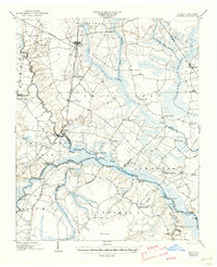
1904 Map of Ayden
USGS Topo · Published 1945About this map
Ayden stands as a rail-centered hub in this early 20th-century landscape, situated along the Kinston Branch (Atlantic Coast Line) as it moves toward Grifton. The regional economy of the period is deeply tied to the intricate drainage of the Neuse River and its major tributaries like Little Contentnea Creek and Swift Creek. This survey reveals an extensive riverine transport network through numerous named landings, including Jollys Old Field Ldg. and Bectons Old Field Landing, which served as vital points for commerce before modern roads were established. The presence of several Tramroads cutting through the Pocoson and swampy lowlands like Clayroot Swamp highlights the active timber and agricultural industries of the era. Smaller rural nodes like Fort Barnwell and Johnsons Mills anchor the southern and central portions of the map, illustrating the dispersed settlement pattern of eastern North Carolina at the time.
Find a feature on this map
62 named features on this map. Tap any name to fly to it.
Don’t see what you’re looking for? This feature index may not catch every label — zoom into the map to look around manually.
Map Details
Editions of this 1904 Ayden Map
4 editions found
Other maps of this area

1901 · New Bern
USGS Topo · 1:62,500

1902 · Ayden
USGS Topo · 1:62,500

1902 · Vanceboro
USGS Topo · 1:62,500

1903 · New Bern
USGS Topo · 1:62,500

1903 · Winterville
USGS Topo · 1:62,500

1903 · Trent River
USGS Topo · 1:62,500

1903 · Chocowinity
USGS Topo · 1:62,500

1904 · Ayden
USGS Topo · 1:62,500

1904 · Trent River
USGS Topo · 1:62,500

1904 · Falkland
USGS Topo · 1:62,500