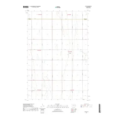
2018 Map of Ayr NE
USGS Topo · Published 2018About this map
Rush River meanders through this agricultural landscape along the Traill and Cass County line during the late 2010s. The region is defined by a precise section-line road grid, including Co Rd 26 and numerous avenues like 151st Ave SE, which facilitate the movement of local harvest. In the eastern portion of the map, the S Br Elm River cuts across the plains near Richtsmeier Airport, a small private landing strip that serves as a modern landmark in this traditional farming territory. The survey meticulously documents the transition from Township 144 North down to Township 142 North, providing a clear view of the drainage patterns and land divisions that have structured life in these North Dakota townships for generations.
Find a feature on this map
28 named features on this map. Tap any name to fly to it.
Don’t see what you’re looking for? This feature index may not catch every label — zoom into the map to look around manually.
Map Details
Editions of this 2018 Ayr NE Map
This is the sole edition of this map. No revisions or reprints were ever made.
Other maps of this area

1918 · Kelso
USGS Topo · 1:62,500

1943 · Kelso
USGS Topo · 1:62,500

1952 · Grand Forks
USGS Topo · 1:250,000

1956 · Grand Forks
USGS Topo · 1:250,000

1966 · Grand Forks
USGS Topo · 1:250,000

1966 · Galesburg
USGS Topo · 1:24,000

1967 · Ayr NE
USGS Topo · 1:24,000

1967 · Blanchard
USGS Topo · 1:24,000

1967 · Ayr NW
USGS Topo · 1:24,000
1967 · Hunter
USGS Topo · 1:24,000