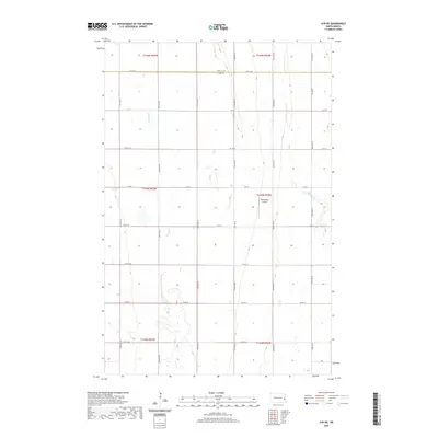
2020 Map of Ayr NE
USGS Topo · Published 2020About this map
Agricultural patterns dominate this Red River Valley landscape, where the Traill County and Cass County line divides the northern and southern portions of the territory. The terrain is defined by its steady, low-gradient drainage, primarily through the winding course of the Rush River and the eastern flow of the S Br Elm River. This area represents the classic Jeffersonian grid of the American Midwest, where section lines dictate the placement of a dense network of gravel roads including 12th St SE and 150th Ave SE. A notable departure from the strictly rural layout is the presence of Richtsmeier Airport, a private landing strip situated among the farmsteads between 151st Ave SE and 152nd Ave SE. This survey reflects the enduring stability of North Dakota's section-line development, where transportation routes such as Co Rd 26 follow the exact paths established during early settlement.
Find a feature on this map
27 named features on this map. Tap any name to fly to it.
Don’t see what you’re looking for? This feature index may not catch every label — zoom into the map to look around manually.
Map Details
Editions of this 2020 Ayr NE Map
This is the sole edition of this map. No revisions or reprints were ever made.
Other maps of this area

1918 · Kelso
USGS Topo · 1:62,500

1943 · Kelso
USGS Topo · 1:62,500

1952 · Grand Forks
USGS Topo · 1:250,000

1956 · Grand Forks
USGS Topo · 1:250,000

1966 · Grand Forks
USGS Topo · 1:250,000

1966 · Galesburg
USGS Topo · 1:24,000

1967 · Ayr NE
USGS Topo · 1:24,000

1967 · Blanchard
USGS Topo · 1:24,000

1967 · Ayr NW
USGS Topo · 1:24,000
1967 · Hunter
USGS Topo · 1:24,000