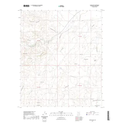
2023 Map of Azotea Peak
USGS Topo · Published 2023About this map
Seven Rivers Hills and the surrounding high desert terrain dominate this part of Eddy County, where a complex network of arroyos and canyons defines the drainage patterns. The seasonal flow of Rocky Arroyo cuts through the landscape, supported by intermittent water sources like Indian Big Spring and Walt Spring. A small marker of early settlement remains at the Rocky Arroyo Cem, situated near the confluence of several draws including Shafer Canyon and Schoolhouse Canyon.
Find a feature on this map
36 named features on this map. Tap any name to fly to it.
Don’t see what you’re looking for? This feature index may not catch every label — zoom into the map to look around manually.
Map Details
Editions of this 2023 Azotea Peak Map
This is the sole edition of this map. No revisions or reprints were ever made.
Other maps of this area

1940 · Bandanna Point
USGS Topo · 1:62,500

1943 · Bandanna Point
USGS Topo · 1:62,500

1943 · West Carlsbad
USGS Topo · 1:62,500

1945 · West Carlsbad
USGS Topo · 1:62,500

1954 · Seven Rivers
USGS Topo · 1:24,000

1954 · Carlsbad
USGS Topo · 1:250,000

1955 · Lake Mc Millan South
USGS Topo · 1:24,000

1957 · Foster Ranch
USGS Topo · 1:24,000

1958 · Carlsbad
USGS Topo · 1:250,000
1978 · Bandanna Point
USGS Topo · 1:24,000