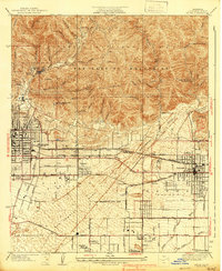
1939 Map of Azusa
USGS Topo · Published 1939About this map
The San Gabriel Mountains rise sharply above the expanding citrus belts and residential grids of the eastern Los Angeles Basin in this late 1930s survey. Specialized health and recreational sites occupy the transition between town and timber, including the Sanatorium and the Canyon Tuberculosis Preventatorium near Bradbury, alongside the South Pasadena Veterans Camp tucked into the foothills. The San Gabriel River and numerous washes like Sawpit Wash define the local topography, while the San Bernardino Base Line provides a key survey anchor for the region.
Find a feature on this map
54 named features on this map. Tap any name to fly to it.
Don’t see what you’re looking for? This feature index may not catch every label — zoom into the map to look around manually.
Map Details
Editions of this 1939 Azusa Map
3 editions found
Other maps of this area

1894 · Los Angeles
USGS Topo · 1:62,500

1894 · Pomona
USGS Topo · 1:62,500

1896 · Pasadena
USGS Topo · 1:62,500

1897 · Pomona
USGS Topo · 1:62,500

1898 · Pomona
USGS Topo · 1:62,500

1900 · Pasadena
USGS Topo · 1:62,500

1900 · Los Angeles
USGS Topo · 1:62,500

1901 · Southern California Sheet No. 1
USGS Topo · 1:250,000

1904 · Pomona
USGS Topo · 1:62,500

1904 · Southern California Sheet No. 1
USGS Topo · 1:250,000