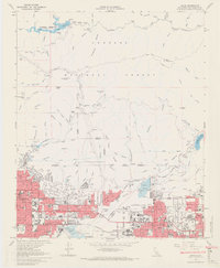
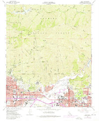
1966 Map of Azusa
USGS Topo · Published 1971About this map
The Angeles National Forest dominates the northern half of this mid-1960s study, where the San Gabriel River carves through steep terrain beneath Monrovia Peak and Mt Bliss. This section of the San Gabriel Mountains is heavily engineered for water management, featuring the Cogswell Reservoir and Morris Reservoir to regulate the flow before it reaches the valley floor. In the southern foothills, the transition from forest to urban settlement is sharp, defined by the expanding borders of Monrovia, Duarte, and Azusa. These communities are threaded together by the Atchison Topeka And Santa Fe and Southern Pacific railroads, which parallel major thoroughfares like Foothill Blvd. Notable regional institutions such as the City of Hope National Medical Center, Citrus Jr College, and Azusa Pacific College highlight the area's mid-century development as a hub for education and healthcare in Los Angeles County.
Find a feature on this map
59 named features on this map. Tap any name to fly to it.
Don’t see what you’re looking for? This feature index may not catch every label — zoom into the map to look around manually.
Map Details
Editions of this 1966 Azusa Map
5 editions found
Other maps of this area

1894 · Los Angeles
USGS Topo · 1:62,500

1894 · Pomona
USGS Topo · 1:62,500

1896 · Pasadena
USGS Topo · 1:62,500

1897 · Pomona
USGS Topo · 1:62,500

1898 · Pomona
USGS Topo · 1:62,500

1900 · Pasadena
USGS Topo · 1:62,500

1900 · Tujunga
USGS Topo · 1:62,500

1900 · Los Angeles
USGS Topo · 1:62,500

1901 · Southern California Sheet No. 1
USGS Topo · 1:250,000

1903 · Rock Creek
USGS Topo · 1:62,500