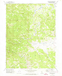
1972 Map of Babcock Peak
USGS Topo · Published 1974About this map
Babcock Peak and the high-elevation basin of Squaw Valley dominate this mountain landscape within the Plumas National Forest. The topography is defined by the drainage systems of Last Chance Creek and Squaw Queen Creek, which flow through a region marked by numerous named water sources such as Murdock Crossing Spring and Poison Creek Spring. This 1972 survey, field-checked by the U.S. Geological Survey, reveals a network of high-country infrastructure, including a prominent Old Railroad Grade and the Notson Bridge. The presence of these routes alongside a Prospect near Babcock Meadows indicates a history of resource extraction and transit through the Sierras. Researchers can also locate remote landmarks like Papoose Peak and the winding Jeep Trail that navigated the complex terrain before more modern road developments.
Find a feature on this map
23 named features on this map. Tap any name to fly to it.
Don’t see what you’re looking for? This feature index may not catch every label — zoom into the map to look around manually.
Map Details
Editions of this 1972 Babcock Peak Map
3 editions found
Other maps of this area

1886 · Honey Lake
USGS Topo · 1:250,000

1890 · Sierraville
USGS Topo · 1:125,000

1891 · Downieville
USGS Topo · 1:125,000

1891 · Honey Lake
USGS Topo · 1:250,000

1892 · Sierraville
USGS Topo · 1:125,000

1893 · Honey Lake
USGS Topo · 1:250,000

1893 · Downieville
USGS Topo · 1:125,000

1894 · Sierraville
USGS Topo · 1:125,000

1895 · Downieville
USGS Topo · 1:125,000

1896 · Downieville
USGS Topo · 1:125,000