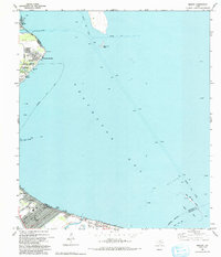
1993 Map of Bacliff
USGS Topo · Published 1993About this map
Galveston Bay dominates this coastal landscape, illustrating the intricate relationship between maritime industry and residential growth in the early 1990s. The shoreline is punctuated by established communities such as Bacliff, San Leon, and Seabrook, while the expansive Oil Field to the east highlights the region's energy-driven economy. Navigational markers like the Houston Ship Channel and Fivemile Cut carve through the water, leading toward landmarks such as the Houston Yacht Club and Bulkhead Reef.
Find a feature on this map
38 named features on this map. Tap any name to fly to it.
Don’t see what you’re looking for? This feature index may not catch every label — zoom into the map to look around manually.
Map Details
Editions of this 1993 Bacliff Map
This is the sole edition of this map. No revisions or reprints were ever made.
Other maps of this area

1916 · Morgan Point
USGS Topo · 1:24,000

1916 · Seabrook
USGS Topo · 1:24,000

1916 · La Porte
USGS Topo · 1:24,000

1919 · Morgan Point
USGS Topo · 1:31,680

1920 · Seabrook
USGS Topo · 1:31,680

1920 · La Porte
USGS Topo · 1:31,680

1929 · Dickinson
USGS Topo · 1:24,000

1929 · Texas City
USGS Topo · 1:24,000

1932 · Clifton By The Sea
USGS Topo · 1:31,680

1932 · Dickinson
USGS Topo · 1:31,680