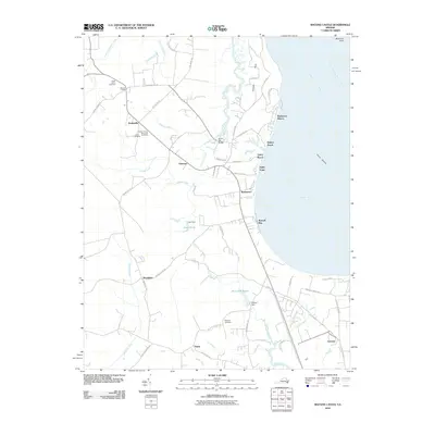
2010 Map of Bacons Castle
USGS Topo · Published 2010About this map
The historic settlement of Bacons Castle and the surrounding Isle of Wight County landscape appear in this 2010 survey along the southern shore of the James River. This area is defined by its relationship with the water, featuring prominent coastal points like Mulberry Point and the wide expanse of Burwell Bay. Inland, the terrain is carved by numerous waterways including Lawnes Creek and the Pagan River, which supported early industrial sites such as Wrenns Millpond and the nearby Wrenns Dam. For genealogists, the map identifies several significant burial grounds, including Lower Surry Cemetery, Hickory Grove Memorial Cemetery, and Jones Cemetery. Local road networks like Bacons Castle TRL and Old Stage Hwy connect small communities such as Rushmere, Moonlight, and Genovar, reflecting the long-standing agricultural and maritime character of this Virginia coastal plain.
Find a feature on this map
65 named features on this map. Tap any name to fly to it.
Don’t see what you’re looking for? This feature index may not catch every label — zoom into the map to look around manually.
Map Details
Editions of this 2010 Bacons Castle Map
This is the sole edition of this map. No revisions or reprints were ever made.
Other maps of this area

1907 · Yorktown
USGS Topo · 1:62,500

1919 · Smithfield
USGS Topo · 1:62,500

1919 · Surry
USGS Topo · 1:62,500

1920 · Ivor
USGS Topo · 1:62,500

1943 · Yorktown
USGS Topo · 1:62,500

1943 · Richmond
USGS Topo · 1:250,000

1944 · Yorktown
USGS Topo · 1:24,000

1944 · Smithfield
USGS Topo · 1:24,000

1944 · Raynor
USGS Topo · 1:24,000
1945 · Raynor
USGS Topo · 1:31,680