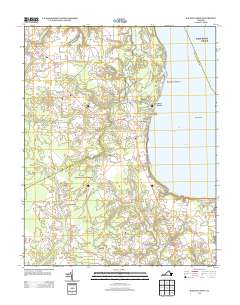
2013 Map of Bacons Castle
USGS Topo · Published 2013About this map
Bacons Castle and the nearby settlement of Poolesville anchor the western reaches of this landscape, where the historic road network of Colonial Trl E and Hog Island Rd defines the local geography. The area transitions from interior crossroads like Genovar and Moonlight toward the tidal influence of the James River. Along the eastern shore, the community of Rushmere overlooks Burwell Bay, a stretch of coastline marked by Tylers Beach and Baileys Beach. The terrain is deeply etched by a network of creeks, including Lawnes Cr and Pooles Cr, which feed into the river. Notable crossings such as the Burnt Mill Bridge and the marshy expanses around Lawnes Neck illustrate the persistence of older rural transit patterns. Further south, the Pagan River and Blairs Cr frame the smaller settlements of Septa and Lawson as the land slopes toward the coastal marshes.
Find a feature on this map
34 named features on this map. Tap any name to fly to it.
Don’t see what you’re looking for? This feature index may not catch every label — zoom into the map to look around manually.
Map Details
Editions of this 2013 Bacons Castle Map
This is the sole edition of this map. No revisions or reprints were ever made.
Other maps of this area

1907 · Yorktown
USGS Topo · 1:62,500

1919 · Smithfield
USGS Topo · 1:62,500

1919 · Surry
USGS Topo · 1:62,500

1920 · Ivor
USGS Topo · 1:62,500

1943 · Yorktown
USGS Topo · 1:62,500

1943 · Richmond
USGS Topo · 1:250,000

1944 · Yorktown
USGS Topo · 1:24,000

1944 · Smithfield
USGS Topo · 1:24,000

1944 · Raynor
USGS Topo · 1:24,000
1945 · Raynor
USGS Topo · 1:31,680