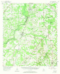
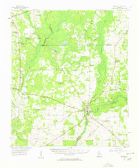
1956 Map of Baconton
USGS Topo · Published 1970About this map
The Flint River carves a winding path through this corner of Southwest Georgia, anchoring a landscape where agriculture and transport networks intersect. In the mid-1950s, the Atlantic Coast Line railroad and the Franklin D Roosevelt Highway ran parallel through the heart of Baconton and Dewitt, serving the region's shipping needs. The map reveals a dense social infrastructure defined by numerous country churches, including the uniquely named Noahs Ark Ch, Beautiful Light Ch, and Habakkuk Ch. In the southeastern portion, the terrain shifts near Sale City and the geological depressions of Oaky Sinks. Notable water features like Wethington Slough and Raccoon Creek feed into the river system, while old travel routes like Stagecoach Road suggest the deeper history of local movement before modern paving.
Find a feature on this map
56 named features on this map. Tap any name to fly to it.
Don’t see what you’re looking for? This feature index may not catch every label — zoom into the map to look around manually.
Map Details
Editions of this 1956 Baconton Map
2 editions found
Other maps of this area

1953 · Dothan
USGS Topo · 1:250,000

1953 · Waycross
USGS Topo · 1:250,000

1954 · Dothan
USGS Topo · 1:250,000

1955 · Dothan
USGS Topo · 1:250,000
1956 · Albany East
USGS Topo · 1:24,000
1956 · Albany West
USGS Topo · 1:24,000
1956 · Baconton
USGS Topo · 1:62,500
1956 · Newton
USGS Topo · 1:62,500

1956 · Sylvester
USGS Topo · 1:62,500
1956 · Sasser
USGS Topo · 1:62,500