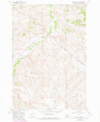
1967 Map of Badbaby Coulee
USGS Topo · Published 1980About this map
Crow Indian Res land defines this section of the Montana landscape, where the deeply carved drainage systems of the Yellowstone River basin shape the topography. The terrain is dominated by a complex network of dry washes and seasonal waterways, most notably Badbaby Coulee and Cashen Coulee, which cut through the high plains toward Pryor Creek. This 1967 survey, updated with 1978 aerial revisions, shows a largely undeveloped ranching or grazing environment where human infrastructure is limited to the Coburn Road and a significant Pipeline corridor crossing the southern reaches. The map identifies localized land use through features like a Pit and a Radio Tower, while the named coulees—including Jane Coulee, Sue Coulee, and Smitty Coulee—suggest a history of local nomenclature tied to the individuals who moved through these breaks. Water management is evidenced by a Ditch and the winding course of Alkali Creek, providing essential orientation for researchers of regional land allotments and drainage patterns.
Find a feature on this map
16 named features on this map. Tap any name to fly to it.
Don’t see what you’re looking for? This feature index may not catch every label — zoom into the map to look around manually.
Map Details
Editions of this 1967 Badbaby Coulee Map
2 editions found
Other maps of this area

1893 · Huntley
USGS Topo · 1:125,000

1954 · Billings
USGS Topo · 1:250,000

1956 · Billings East
USGS Topo · 1:24,000

1957 · Billings
USGS Topo · 1:250,000

1958 · Billings
USGS Topo · 1:250,000

1967 · Soda Springs NW
USGS Topo · 1:24,000

1967 · Soda Springs
USGS Topo · 1:24,000

1967 · Cottonwood Creek
USGS Topo · 1:24,000
1967 · Badbaby Coulee
USGS Topo · 1:24,000
1967 · Vale Creek Ranch
USGS Topo · 1:24,000