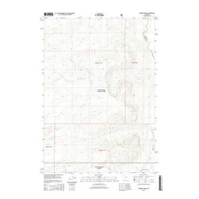
2015 Map of Badger Creek
USGS Topo · Published 2015About this map
The Yellowstone River winds through the eastern edge of this 2015 survey, marking a significant hydrological corridor within the Teton County wilderness. This high-altitude landscape is defined by its complex drainage network, where Badger Cr and Phlox Cr intersect the rugged terrain, flowing toward the larger river system. The presence of Chipmunk Cr further illustrates the intricate watershed patterns characteristic of this part of Wyoming. This map serves as a primary record of the undeveloped back-country as it existed in the early 21st century, focusing on the natural topography and the preservation of original watercourse names within the protected lands of the Yellowstone National Park and surrounding forest areas.
Find a feature on this map
4 named features on this map. Tap any name to fly to it.
Don’t see what you’re looking for? This feature index may not catch every label — zoom into the map to look around manually.
Map Details
Editions of this 2015 Badger Creek Map
This is the sole edition of this map. No revisions or reprints were ever made.
Other maps of this area

1885 · Lake
USGS Topo · 1:125,000

1895 · Lake
USGS Topo · 1:125,000

1896 · Lake
USGS Topo · 1:125,000

1901 · Lake
USGS Topo · 1:125,000

1906 · Lake
USGS Topo · 1:125,000

1911 · Lake
USGS Topo · 1:125,000

1955 · Ashton
USGS Topo · 1:250,000

1958 · Ashton
USGS Topo · 1:250,000
1959 · Mount Hancock
USGS Topo · 1:62,500
1959 · Two Ocean Pass
USGS Topo · 1:62,500