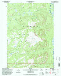
1996 Map of Badger Creek
USGS Topo · Published 1998About this map
The Continental Divide winds through this high-elevation landscape where the waters of the Yellowstone River and Snake River drain toward opposite sides of the continent. Located within the southeastern reaches of Yellowstone National Park, this area is defined by the massive Two Ocean Plateau, a high tableland that separates major drainage basins. This 1990s survey illustrates a wild, roadless interior where movement is dictated by historic paths like the Two Ocean Plateau Trail and the South Boundary Trail. These routes connect remote water features such as Mariposa Lake and Plateau Falls. The map documents the boundary between the park and the Teton National Forest, specifically within the Teton Wilderness, capturing the drainage patterns of numerous mountain streams including Chipmunk Creek, Badger Creek, and Falcon Creek.
Find a feature on this map
21 named features on this map. Tap any name to fly to it.
Don’t see what you’re looking for? This feature index may not catch every label — zoom into the map to look around manually.
Map Details
Editions of this 1996 Badger Creek Map
This is the sole edition of this map. No revisions or reprints were ever made.
Other maps of this area

1885 · Lake
USGS Topo · 1:125,000

1895 · Lake
USGS Topo · 1:125,000

1896 · Lake
USGS Topo · 1:125,000

1901 · Lake
USGS Topo · 1:125,000

1906 · Lake
USGS Topo · 1:125,000

1911 · Lake
USGS Topo · 1:125,000

1955 · Ashton
USGS Topo · 1:250,000

1958 · Ashton
USGS Topo · 1:250,000
1959 · Mount Hancock
USGS Topo · 1:62,500
1959 · Two Ocean Pass
USGS Topo · 1:62,500