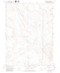
1966 Map of Badger Mtn NW
USGS Topo · Published 1979About this map
Bitner Ranch serves as a lone human outpost in this high-desert reach of Washoe County, situated along the western edge of the Charles Sheldon Antelope Range. The landscape is dominated by the broad upland of Bitner Table and the drainage network of Badger Creek, which flows through the Antelope Range toward the east. This 1960s field survey documents a terrain defined by its water sources, marking essential landmarks like Post Camp Spring, North Spring, and Fatty Martin Lake. A network of primitive trails and jeep trails provides the only access through the canyons, including Wall Canyon and Badger Canyon, reflecting the area's primary use for ranching and wildlife management. The mapping of gravel pits and numerous survey benchmarks indicates the ongoing maintenance of these remote routes within the federal antelope refuge.
Find a feature on this map
28 named features on this map. Tap any name to fly to it.
Don’t see what you’re looking for? This feature index may not catch every label — zoom into the map to look around manually.
Map Details
Editions of this 1966 Badger Mtn NW Map
2 editions found
Other maps of this area

1889 · Long Valley
USGS Topo · 1:250,000

1954 · Vya
USGS Topo · 1:250,000

1958 · Vya
USGS Topo · 1:250,000

1962 · Vya
USGS Topo · 1:250,000

1966 · Bald Mountain
USGS Topo · 1:24,000

1966 · Swan Lake
USGS Topo · 1:24,000

1966 · Badger Mtn NW
USGS Topo · 1:24,000

1966 · Massacre Lake
USGS Topo · 1:24,000

1966 · Blowout Mtn
USGS Topo · 1:24,000

1966 · Nut Mountain
USGS Topo · 1:24,000