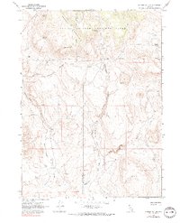
1966 Map of Badger Mtn SE
USGS Topo · Published 1990About this map
The Charles Sheldon Antelope Range dominates this mid-1960s survey, a landscape defined by an intricate network of desert water sources and canyons. The Washoe Co Humboldt Co border runs through the heart of this high-altitude basin, where an Indefinite Boundary reflects the challenging nature of surveying this terrain. Life in this arid environment centered on named water features like Domingo Spring, Bateman Spring, and Wheeler Spring, which provided essential stops along the winding Jeep Trail and the established Badger Mountain Trail. A lone Prospect near Wall Canyon suggests the mineral exploration common to this era in northern Nevada. The drainage pattern is marked by dramatic features such as Wildcat Gorge and the confluence of Shoestring Valley Creek and Butcher Flat Creek, illustrating the seasonal waterflow that carved the high desert floor.
Find a feature on this map
22 named features on this map. Tap any name to fly to it.
Don’t see what you’re looking for? This feature index may not catch every label — zoom into the map to look around manually.
Map Details
Editions of this 1966 Badger Mtn SE Map
3 editions found
Other maps of this area

1889 · Long Valley
USGS Topo · 1:250,000

1954 · Vya
USGS Topo · 1:250,000

1958 · Vya
USGS Topo · 1:250,000

1962 · Vya
USGS Topo · 1:250,000

1965 · Rock Spring Table
USGS Topo · 1:62,500

1966 · Badger Mtn NW
USGS Topo · 1:24,000

1966 · Blowout Mtn
USGS Topo · 1:24,000

1966 · Nut Mountain
USGS Topo · 1:24,000

1966 · Badger Mtn SE
USGS Topo · 1:24,000

1972 · Soldier Meadow
USGS Topo · 1:24,000