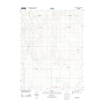
2013 Map of Badger Wash
USGS Topo · Published 2013About this map
Government Highline Canal cuts across the arid landscape of western Colorado, marking a significant piece of irrigation infrastructure designed to transform the high desert. This 2013 survey of the border region between Garfield and Mesa counties illustrates a transition from the narrow draws of Prairie Canyon into the broader expanse of the Grand Valley. The drainage patterns are defined by a network of seasonal waterways including West Salt Creek, Badger Wash, and Dry Canyon Wash, which feed toward the Colorado River valley. A grid of local roads, such as Baxter Pass Rd and Mitchell Rd, provides access across the public land survey system blocks. The map reveals the stark contrast between the engineered flow of the canal and the natural, winding paths of the salt creeks and washes that have shaped the local topography over millennia.
Find a feature on this map
30 named features on this map. Tap any name to fly to it.
Don’t see what you’re looking for? This feature index may not catch every label — zoom into the map to look around manually.
Map Details
Editions of this 2013 Badger Wash Map
This is the sole edition of this map. No revisions or reprints were ever made.
Other maps of this area

1885 · East Tavaputs
USGS Topo · 1:250,000

1956 · Grand Junction
USGS Topo · 1:250,000

1959 · Grand Junction
USGS Topo · 1:250,000

1960 · Grand Junction
USGS Topo · 1:250,000

1962 · Grand Junction
USGS Topo · 1:250,000

1962 · Mack
USGS Topo · 1:24,000

1964 · Grand Junction
USGS Topo · 1:250,000

1965 · Grand Junction
USGS Topo · 1:250,000

1968 · Badger Wash
USGS Topo · 1:24,000
1968 · Carbonera
USGS Topo · 1:24,000