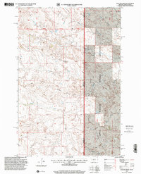
1997 Map of Badland Draw
USGS Topo · Published 2001About this map
Little Missouri National Grassland dominates the eastern portion of this late 20th-century landscape, where the high plains of eastern Fallon County meet the North Dakota border. The terrain is defined by a complex network of ephemeral drainage systems and erosion-carved landmarks, most notably Badland Draw and the prominent Haystack Butte. This era of the survey reflects a landscape largely preserved for public use and grazing, characterized by a lack of dense settlement but a high density of named geographic features. The map traces the upper reaches of the Cannonball River and Cottonwood Creek, alongside smaller tributaries like Johny Creek and Dugout Creek. From the heights of Windy Ridge to the bottomlands of Mud Creek, the area showcases the classic badlands topography of the northern Missouri Plateau, documented here with precision by the U.S. Geological Survey and USDA Forest Service.
Find a feature on this map
14 named features on this map. Tap any name to fly to it.
Don’t see what you’re looking for? This feature index may not catch every label — zoom into the map to look around manually.
Map Details
Editions of this 1997 Badland Draw Map
This is the sole edition of this map. No revisions or reprints were ever made.
Other maps of this area

1953 · Miles City
USGS Topo · 1:250,000

1953 · Dickinson
USGS Topo · 1:250,000

1957 · Dickinson
USGS Topo · 1:250,000

1957 · Miles City
USGS Topo · 1:250,000

1958 · Miles City
USGS Topo · 1:250,000

1980 · Pretty Butte
USGS Topo · 1:24,000

1980 · Marmarth
USGS Topo · 1:24,000

1980 · Belfield
USGS Topo · 1:100,000

1981 · Baker
USGS Topo · 1:100,000

1981 · Buffalo Reservoir
USGS Topo · 1:24,000