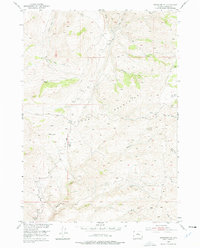
1952 Map of Badwater NE
USGS Topo · Published 1977About this map
Bighorn Mountains topography dominates this 1952 survey of Natrona County, revealing a landscape defined by livestock operations and seasonal mountain camps. The map traces the Bighorn Trail as it winds through the high country, connecting several remote outposts such as Carlson Cabin, Larson Cabin, and Baskett Cabin. These structures, alongside Rats Sheep Camp and LL Sheep Camp, illustrate the historic reliance on this terrain for summer grazing.
Find a feature on this map
34 named features on this map. Tap any name to fly to it.
Don’t see what you’re looking for? This feature index may not catch every label — zoom into the map to look around manually.
Map Details
Editions of this 1952 Badwater NE Map
2 editions found
Other maps of this area

1952 · Deadman Butte
USGS Topo · 1:24,000

1952 · Badwater
USGS Topo · 1:24,000

1952 · Grave Spring
USGS Topo · 1:24,000

1952 · Sioux Pass
USGS Topo · 1:24,000

1952 · Badwater NE
USGS Topo · 1:24,000

1952 · Badwater SE
USGS Topo · 1:24,000

1955 · Arminto
USGS Topo · 1:250,000

1958 · Arminto
USGS Topo · 1:250,000

1962 · Arminto
USGS Topo · 1:250,000
1967 · Cornell Gulch
USGS Topo · 1:24,000