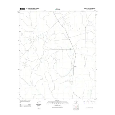
2012 Map of Baggett Ranch
USGS Topo · Published 2012About this map
Baggett Ranch sits at the heart of this Crockett County landscape, a region defined by its expansive drainage systems and sparse interior road network. The map reveals the path of Ranch Road 1973 and State Route 163 as they navigate a terrain marked by significant seasonal waterways. These desert washes, including the prominent Live Oak Draw and Tucker Draw, illustrate the intricate hydrography that dictates land use in this part of West Texas. The presence of secondary routes like Co RD 401 highlights the essential infrastructure required to connect these isolated ranching outposts. This survey provides an exact look at the property boundaries and geographic landmarks that have supported the local livestock industry into the early 21st century.
Find a feature on this map
6 named features on this map. Tap any name to fly to it.
Don’t see what you’re looking for? This feature index may not catch every label — zoom into the map to look around manually.
Map Details
Editions of this 2012 Baggett Ranch Map
This is the sole edition of this map. No revisions or reprints were ever made.
Other maps of this area

1954 · Sonora
USGS Topo · 1:250,000

1958 · Sonora
USGS Topo · 1:250,000

1967 · Ozona
USGS Topo · 1:24,000

1967 · Baggett Ranch
USGS Topo · 1:24,000

1967 · Ozona SE
USGS Topo · 1:24,000

1967 · Hunt Ranch
USGS Topo · 1:24,000

1967 · Crockett Heights
USGS Topo · 1:24,000
1967 · Mitchell Canyon NE
USGS Topo · 1:24,000

1969 · Wild Horse Canyon
USGS Topo · 1:24,000

1970 · Howards Well NE
USGS Topo · 1:24,000