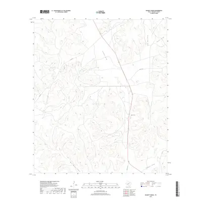
2019 Map of Baggett Ranch
USGS Topo · Published 2019About this map
Baggett Ranch sits at the heart of this West Texas landscape, positioned within a complex network of intermittent watercourses that define the ranching country of Crockett County. The topography is dominated by deep drainage systems including Johnson Draw, Tucker Draw, and the eponymous Baggett Draw, which carve through the high plateau. To the southwest, the dramatic relief of Bert Mertz Canyon illustrates the erosive power of the region's seasonal runoff. Infrastructure in this part of the Edwards Plateau is sparse, consisting primarily of Ranch Rd 1973 and rural tracks like Co Rd 401 that connect isolated ranch headquarters across the wide-open terrain. The map detail reflects the long-standing livestock heritage of the area, where land use is dictated by the availability of water in the draws and the ruggedness of the local canyons.
Find a feature on this map
9 named features on this map. Tap any name to fly to it.
Don’t see what you’re looking for? This feature index may not catch every label — zoom into the map to look around manually.
Map Details
Editions of this 2019 Baggett Ranch Map
This is the sole edition of this map. No revisions or reprints were ever made.
Other maps of this area

1954 · Sonora
USGS Topo · 1:250,000

1958 · Sonora
USGS Topo · 1:250,000

1967 · Ozona
USGS Topo · 1:24,000

1967 · Baggett Ranch
USGS Topo · 1:24,000

1967 · Ozona SE
USGS Topo · 1:24,000

1967 · Hunt Ranch
USGS Topo · 1:24,000

1967 · Crockett Heights
USGS Topo · 1:24,000
1967 · Mitchell Canyon NE
USGS Topo · 1:24,000

1969 · Wild Horse Canyon
USGS Topo · 1:24,000

1970 · Howards Well NE
USGS Topo · 1:24,000