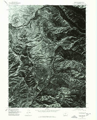
1975 Map of Baggs NE
USGS Topo · Published 1978About this map
Smiley Draw dominates the drainage patterns of this high-altitude Wyoming terrain, captured in a mid-1970s orthophotomap that emphasizes the physical geometry of the land over human development. This specific quadrangle reflects a period of meticulous aerial surveying by the U.S. Geological Survey, using 1:80,000 scale photography to document the complex erosion and ridge lines of the Carbon County landscape. While many contemporary topographic maps focus on roads and structures, this orthophoto provides a direct visual record of the natural surface, showing the intricate shadows and textures of the basins and draws that defined the region before later industrial or infrastructure changes. It is a stark, utilitarian document of the western wilderness, recording the exact state of the soil and vegetation as it appeared on August 29, 1975.
Find a feature on this map
1 named feature on this map. Tap any name to fly to it.
Don’t see what you’re looking for? This feature index may not catch every label — zoom into the map to look around manually.
Map Details
Editions of this 1975 Baggs NE Map
This is the sole edition of this map. No revisions or reprints were ever made.
Other maps of this area

1932 · Savery
USGS Topo · 1:96,000

1940 · Savery
USGS Topo · 1:125,000

1954 · Rawlins
USGS Topo · 1:250,000

1957 · Baggs
USGS Topo · 1:62,500

1957 · Doty Mountain
USGS Topo · 1:62,500

1958 · Rawlins
USGS Topo · 1:250,000
1961 · Savery
USGS Topo · 1:24,000
1961 · Browns Hill
USGS Topo · 1:24,000

1961 · Ketchum Buttes
USGS Topo · 1:24,000

1962 · Rawlins
USGS Topo · 1:250,000