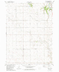
1982 Map of Bagley NW
USGS Topo · Published 1983About this map
Greenbrier United Ch serves as a central landmark in this 1980s landscape, situated within a region defined by the drainage of the North Raccoon River. The terrain is characterized by a network of waterways, including Greenbrier Creek, Dead Brier Creek, and Mosquito Creek, which carve through the agricultural townships of Jackson, Grant, and Greenbrier. Public recreation areas such as Henderson County Park and Seven Hills County Park border the river, offering a view of the local topography that includes a Ski Lift and a Golf Course. Genealogists and local historians will find the Greenbrier Cem and German Cem particularly useful for tracing family roots in this rural Greene County area during a period of established land use and agricultural stability.
Find a feature on this map
17 named features on this map. Tap any name to fly to it.
Don’t see what you’re looking for? This feature index may not catch every label — zoom into the map to look around manually.
Map Details
Editions of this 1982 Bagley NW Map
This is the sole edition of this map. No revisions or reprints were ever made.
Other maps of this area

1954 · Bagley
USGS Topo · 1:62,500

1954 · Omaha
USGS Topo · 1:250,000

1954 · Fort Dodge
USGS Topo · 1:250,000

1957 · Omaha
USGS Topo · 1:250,000

1957 · Fort Dodge
USGS Topo · 1:250,000

1958 · Omaha
USGS Topo · 1:250,000

1958 · Fort Dodge
USGS Topo · 1:250,000

1962 · Jefferson
USGS Topo · 1:62,500

1971 · Coon Rapids NE
USGS Topo · 1:24,000

1971 · Bayard
USGS Topo · 1:24,000