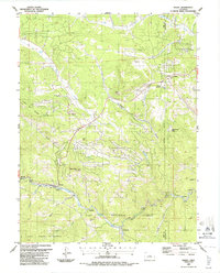
1987 Map of Bailey
USGS Topo · Published 1987About this map
The North Fork South Platte River carves a deep path through this 1987 survey, serving as a corridor for small communities like Bailey, Insmont, and Estabrook. Much of the surrounding landscape is protected within the Pike National Forest and the Lost Creek Wilderness, where terrain ranges from Mount Bailey to Crooked Top Mountain. The map illustrates the varied development of the late 1980s, including residential pockets like Wandrest Park and Silver Springs near the junction of mountain roads. Local history and industry are represented by scattered mine prospects and gravel pits, along with utility markers like an Observatory and Sewage Disposal plant. The boundary between Park and Jefferson Counties bisects the northeastern corner near Pine Junction, highlighting how topography dictated settlement patterns along the gulches and creeks that feed the South Platte.
Find a feature on this map
45 named features on this map. Tap any name to fly to it.
Don’t see what you’re looking for? This feature index may not catch every label — zoom into the map to look around manually.
Map Details
Editions of this 1987 Bailey Map
2 editions found
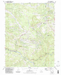
Other maps of this area

1893 · Platte Canyon
USGS Topo · 1:125,000

1899 · West Denver
USGS Topo · 1:125,000

1903 · Georgetown
USGS Topo · 1:62,500

1905 · Georgetown
USGS Topo · 1:62,500

1945 · Pine
USGS Topo · 1:24,000

1945 · Bailey
USGS Topo · 1:24,000

1945 · Shawnee
USGS Topo · 1:24,000

1948 · Pine
USGS Topo · 1:24,000

1948 · Shawnee
USGS Topo · 1:24,000

1949 · Bailey
USGS Topo · 1:24,000