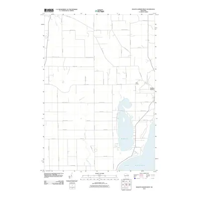
2010 Map of Baileys Harbor West
USGS Topo · Published 2010About this map
Kangaroo Lake dominates the central landscape of this Door County peninsula survey, situated just inland from the rocky shoreline of Lake Michigan. The settlement of Baileys Harbor sits on the eastern edge of the quadrangle, serving as a focal point for the local road network that includes County Hwy-A and County Hwy-EE. The area is defined by its coastal drainage patterns, with Hibbard Creek, Piel Creek, and Heins Creek carving paths toward the lake. Genealogists and local historians can locate the Baileys Harbor Cemetery positioned along Red Cherry Rd, while the surrounding terrain is a patchwork of wooded lots and clearings accessed by numerous local lanes such as Peninsula Players Rd and Juddville Rd.
Find a feature on this map
51 named features on this map. Tap any name to fly to it.
Don’t see what you’re looking for? This feature index may not catch every label — zoom into the map to look around manually.
Map Details
Editions of this 2010 Baileys Harbor West Map
This is the sole edition of this map. No revisions or reprints were ever made.
Other maps of this area

1954 · Escanaba
USGS Topo · 1:250,000

1954 · Manitowoc
USGS Topo · 1:250,000

1957 · Escanaba
USGS Topo · 1:250,000

1958 · Escanaba
USGS Topo · 1:250,000

1958 · Manitowoc
USGS Topo · 1:250,000

1960 · Sturgeon Bay
USGS Topo · 1:62,500

1960 · Jacksonport
USGS Topo · 1:62,500

1960 · Sister Bay
USGS Topo · 1:62,500

1961 · Chambers Island
USGS Topo · 1:62,500

1981 · Institute
USGS Topo · 1:24,000