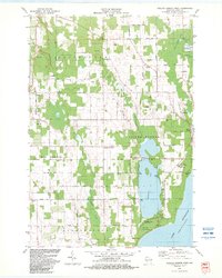
1982 Map of Baileys Harbor West
USGS Topo · Published 1983About this map
Kangaroo Lake dominates the central landscape of this Door County peninsula survey, its waters feeding into Heins Creek as it moves toward the Lake Michigan shoreline. The area exhibits a mix of preserved natural spaces and local industry, with the northern reaches protected by the Mud Lake State Wildlife Area and Baileys Harbor Swamp, while various quarries and gravel pits dot the townships of Gibraltar and Egg Harbor.
Find a feature on this map
52 named features on this map. Tap any name to fly to it.
Don’t see what you’re looking for? This feature index may not catch every label — zoom into the map to look around manually.
Map Details
Editions of this 1982 Baileys Harbor West Map
This is the sole edition of this map. No revisions or reprints were ever made.
Other maps of this area

1954 · Escanaba
USGS Topo · 1:250,000

1954 · Manitowoc
USGS Topo · 1:250,000

1957 · Escanaba
USGS Topo · 1:250,000

1958 · Escanaba
USGS Topo · 1:250,000

1958 · Manitowoc
USGS Topo · 1:250,000

1960 · Sturgeon Bay
USGS Topo · 1:62,500

1960 · Jacksonport
USGS Topo · 1:62,500

1960 · Sister Bay
USGS Topo · 1:62,500

1961 · Chambers Island
USGS Topo · 1:62,500

1981 · Institute
USGS Topo · 1:24,000