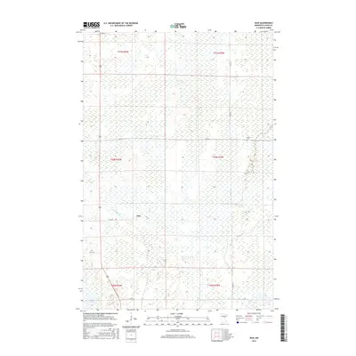
2016 Map of Bain
USGS Topo · Published 2016About this map
Bain sits at the intersection of a vast wetland landscape and local transit routes in this 2016 survey of Aitkin County. The settlement pattern here is sparse, characterized by long, straight roadways such as Co RD 68 and 320th PL that cut through the low-lying terrain. The hydrography is dominated by the meandering White Elk Cr and isolated bodies of water like Sitas Lake and Clear Lake, which dictate the placement of local homesteads and access roads. Genealogists and local historians can locate the Hebron Cem in the northeastern portion of the quadrangle, a significant landmark for tracing early residents in this section of the Minnesota Northwoods. The map provides a clear look at the township and range divisions, illustrating how the Public Land Survey System organized this remote corner of the state.
Find a feature on this map
18 named features on this map. Tap any name to fly to it.
Don’t see what you’re looking for? This feature index may not catch every label — zoom into the map to look around manually.
Map Details
Editions of this 2016 Bain Map
This is the sole edition of this map. No revisions or reprints were ever made.
Other maps of this area

1914 · Aitkin
USGS Topo · 1:62,500

1915 · Aitkin
USGS Topo · 1:62,500

1953 · Duluth
USGS Topo · 1:250,000

1958 · Duluth
USGS Topo · 1:250,000

1970 · Rabey
USGS Topo · 1:24,000

1970 · Palisade
USGS Topo · 1:24,000

1970 · Sanders Lake
USGS Topo · 1:24,000

1970 · Bain
USGS Topo · 1:24,000
1970 · Hill City
USGS Topo · 1:24,000

1970 · White Elk Lake
USGS Topo · 1:24,000