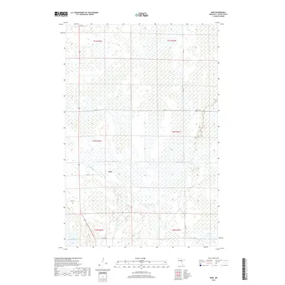
2019 Map of Bain
USGS Topo · Published 2019About this map
Bain is the primary settlement in this section of Aitkin County, situated where Co RD 68 meets the local roadway network near White Elk Cr. The landscape is characterized by extensive wetlands and scattered glacial lakes, typical of this region of northern Minnesota. In the northeastern quadrant, the Hebron Cem sits along 560th ST, serving as a significant landmark for genealogical research and local history. Water bodies such as Clear Lake in the southeast and Sitas Lake in the southwest punctuate the terrain, which is otherwise dominated by the Public Land Survey System grids of townships like t50n r26w. The distribution of rural routes, including 320th PL and 510th LN, reveals a sparse settlement pattern tied to the low-lying, water-rich environment.
Find a feature on this map
18 named features on this map. Tap any name to fly to it.
Don’t see what you’re looking for? This feature index may not catch every label — zoom into the map to look around manually.
Map Details
Editions of this 2019 Bain Map
This is the sole edition of this map. No revisions or reprints were ever made.
Other maps of this area

1914 · Aitkin
USGS Topo · 1:62,500

1915 · Aitkin
USGS Topo · 1:62,500

1953 · Duluth
USGS Topo · 1:250,000

1958 · Duluth
USGS Topo · 1:250,000

1970 · Rabey
USGS Topo · 1:24,000

1970 · Palisade
USGS Topo · 1:24,000

1970 · Sanders Lake
USGS Topo · 1:24,000

1970 · Bain
USGS Topo · 1:24,000
1970 · Hill City
USGS Topo · 1:24,000

1970 · White Elk Lake
USGS Topo · 1:24,000