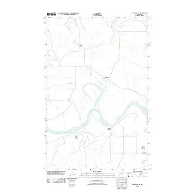
2011 Map of Bainville SW
USGS Topo · Published 2011About this map
The Missouri River carves a winding path through the heart of this Roosevelt County landscape, defining the character of the terrain just north of the state line. At this point in the early 21st century, the area around Lakeside remains predominantly rural, characterized by the deep erosional cuts of Benson Coulee and Sheep Camp Coulee that drain toward the river. Local infrastructure is sparse, centered on gravel routes like S Bainville Rd and the Bainville-Snowden Rd which connect isolated homesteads and water management features. Small-scale hydraulic works such as Belushi Dam and Burgess Reservoir Dam manage the seasonal flows of Little Muddy Creek and its tributaries. For genealogists and local historians, the Nohly Cemetery provides a specific point of reference in the southeastern corner of the quadrangle, serving as a reminder of the generations that have worked this stretch of the Missouri valley.
Find a feature on this map
15 named features on this map. Tap any name to fly to it.
Don’t see what you’re looking for? This feature index may not catch every label — zoom into the map to look around manually.
Map Details
Editions of this 2011 Bainville SW Map
This is the sole edition of this map. No revisions or reprints were ever made.
Other maps of this area

1909 · Glendive
USGS Topo · 1:250,000

1954 · Glendive
USGS Topo · 1:250,000

1954 · Wolf Point
USGS Topo · 1:250,000

1957 · Glendive
USGS Topo · 1:250,000

1958 · Wolf Point
USGS Topo · 1:250,000

1958 · Glendive
USGS Topo · 1:250,000
1968 · Dore
USGS Topo · 1:24,000

1968 · Bainville SE
USGS Topo · 1:24,000

1969 · Cedar Coulee
USGS Topo · 1:24,000

1969 · Bainville SW
USGS Topo · 1:24,000