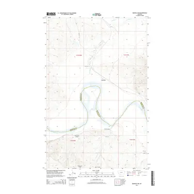
2014 Map of Bainville SW
USGS Topo · Published 2014About this map
The Missouri River carves a sweeping path through this borderland where Roosevelt and Richland counties meet. At the center of the map, the small settlement of Lakeside sits near the drainage of Little Muddy Creek, which winds its way southward from Shotgun Creek. The landscape is defined by deep breaks and draws, notably Benson Coulee and Sheep Camp Coulee, which descend toward the river valley. To the southeast, the historic Nohly Cemetery serves as a localized landmark for genealogists and family historians researching the early occupants of this region. Connectivity is provided by rural corridors like S Bainville Road and County Road 147, which link the high prairie draws to the river flats.
Find a feature on this map
17 named features on this map. Tap any name to fly to it.
Don’t see what you’re looking for? This feature index may not catch every label — zoom into the map to look around manually.
Map Details
Editions of this 2014 Bainville SW Map
This is the sole edition of this map. No revisions or reprints were ever made.
Other maps of this area

1909 · Glendive
USGS Topo · 1:250,000

1954 · Glendive
USGS Topo · 1:250,000

1954 · Wolf Point
USGS Topo · 1:250,000

1957 · Glendive
USGS Topo · 1:250,000

1958 · Wolf Point
USGS Topo · 1:250,000

1958 · Glendive
USGS Topo · 1:250,000
1968 · Dore
USGS Topo · 1:24,000

1968 · Bainville SE
USGS Topo · 1:24,000

1969 · Cedar Coulee
USGS Topo · 1:24,000

1969 · Bainville SW
USGS Topo · 1:24,000