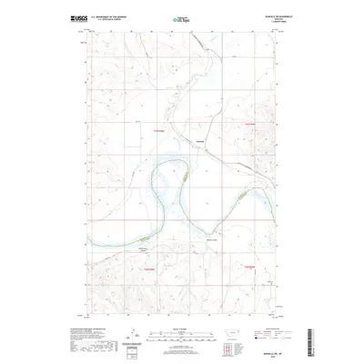
2020 Map of Bainville SW
USGS Topo · Published 2020About this map
The Missouri River carves a sweeping path across this corner of northeast Montana, marking the jurisdictional boundary between Roosevelt and Richland counties. The small settlement of Lakeside serves as a focal point near the northern banks, situated along a network of rural routes including S Bainville Rd and the Bainville-Snowden Rd. This landscape is defined by its drainage systems, where Little Muddy Cr and Shotgun Cr flow through the breaks toward the river valley. To the south, the topography is punctuated by named landforms such as Benson Coulee and Sheep Camp Coulee. For genealogists and local historians, the presence of the Nohly Cem in the southeastern quadrant provides a specific point of interest for tracing early residents in this river-oriented community.
Find a feature on this map
20 named features on this map. Tap any name to fly to it.
Don’t see what you’re looking for? This feature index may not catch every label — zoom into the map to look around manually.
Map Details
Editions of this 2020 Bainville SW Map
This is the sole edition of this map. No revisions or reprints were ever made.
Other maps of this area

1909 · Glendive
USGS Topo · 1:250,000

1954 · Glendive
USGS Topo · 1:250,000

1954 · Wolf Point
USGS Topo · 1:250,000

1957 · Glendive
USGS Topo · 1:250,000

1958 · Wolf Point
USGS Topo · 1:250,000

1958 · Glendive
USGS Topo · 1:250,000
1968 · Dore
USGS Topo · 1:24,000

1968 · Bainville SE
USGS Topo · 1:24,000

1969 · Cedar Coulee
USGS Topo · 1:24,000

1969 · Bainville SW
USGS Topo · 1:24,000