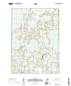
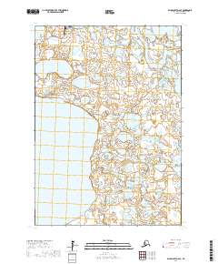
2017 Map of Baird Inlet D-2 NE
USGS Topo · Published 2017About this map
Nunapitchuk sits at the heart of this Yukon-Kuskokwim Delta landscape, characterized by an intricate network of tundra lakes and the meandering Johnson River. The settlement's connection to the wider region is documented through the presence of the Nunapitchuk Airport and the Old Kasigluk-Main Road, which suggests a history of overland and aerial transit in this water-dominant environment. Large bodies of water like Kayigyalik Lake and Nunavakunakslak Lake dominate the northern half of the survey, illustrating the complex hydrology of the Bethel Census Area. The southern margin of the sheet captures the edge of the Kasigluk Airport, indicating the proximity and relationship between neighboring villages in this remote part of Alaska. This 2017 data reflects the modern infrastructure laid over an ancient, shifting drainage pattern.
Find a feature on this map
13 named features on this map. Tap any name to fly to it.
Don’t see what you’re looking for? This feature index may not catch every label — zoom into the map to look around manually.
Map Details
Editions of this 2017 Baird Inlet D-2 NE Map
This is the sole edition of this map. No revisions or reprints were ever made.
Other maps of this area

1951 · Marshall
USGS Topo · 1:250,000

1951 · Baird Inlet
USGS Topo · 1:250,000

1954 · Marshall A-2
USGS Topo · 1:63,360

1954 · Marshall A-1
USGS Topo · 1:63,360

1954 · Marshall
USGS Topo · 1:250,000

1954 · Baird Inlet
USGS Topo · 1:250,000
1954 · Baird Inlet D-1
USGS Topo · 1:63,360
1954 · Baird Inlet D-2
USGS Topo · 1:63,360
2017 · Baird Inlet D-2 SW
USGS Topo · 1:25,000
2017 · Baird Inlet D-2 SE
USGS Topo · 1:25,000